Turkish research team on 9th national Antarctic expedition finishes stop at Dismal Island
ANTARCTICA - RECENT FEB. 2025: The 9th National Antarctic Science Expedition team is continuing its research, which began in early February 2025 and is set to conclude in early March 2025.
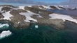
Footage captured by Anadolu during the expedition highlights both the unique beauty and the challenging conditions faced by the team in Antarctica.
The team embarked on their journey from King George Island, navigating through Le Maire Channel, Penola Strait, and Grandidier Channel before reaching Dismal Island.
Upon arriving on the third day, the team collected data from the Global Navigation Satellite System (GNSS) station, which had stored information for a year, and conducted necessary maintenance.
Expedition leader Hasan Hakan Yavaşoğlu explained that the GNSS data allows for
monitoring deformations caused by tectonic and isostatic pressure changes in the region.
One of the team members Abdullah Kellevezir, noted that the team observed the West Antarctic Plate moving northeastward at a rate of about 1–1.5 cm per year.
Following their studies, the team sailed to Türkiye's scientific research camp on Horseshoe Island, located 40 nautical miles from Dismal Island. (Footage by Sebnem Coskun/Anadolu Agency via Getty Images)


PURCHASE A LICENSE
Get personalized pricing by telling us when, where, and how you want to use this asset.
DETAILS
Restrictions:
NO SALES IN TÜRKİYE.
Credit:
Editorial #:
2200581774
Collection:
Anadolu
Date created:
February 19, 2025
Upload date:
License type:
Rights-ready
Release info:
Not released.��More information
Clip length:
00:03:52:15
Location:
Antarctica
Mastered to:
MPEG-4 8-bit H.264 HD 1920x1080 25p
Source:
Anadolu Video
Object name:
antartika
- Glacier,
- Antarctica,
- Biology,
- Climate Change,
- Color Image,
- Drone,
- Drone Point of View,
- Editorial,
- Exploration,
- Film - Moving Image,
- HD Format,
- Horizontal,
- Human Interest,
- Ice,
- Nature,
- Penguin,
- Produced Segment,
- Real Time Video,
- Research,
- Sailing,
- Science,
- Science and Technology,
- Scientific Exploration,
- Scientist,
- Snow,
- Türkiye - Country,
- Video with Sound,
- Whale,