Bangkok, Thailand, satellite image - HD stock video
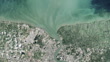
Bangkok, Thailand. Satellite image centred on Bangkok, the capital city of Thailand, showing the Bang Kachao conservation area (dark, lower centre) surrounded by an old meander of the Chao Phraya River (dark line, vertical). Bang Kachao is a lush protected area that has escaped the dense development seen elsewhere in Bangkok. The Bay of Bangkok (Bight of Bangkok, bottom) and Suvarnabhumi airport (rectangular, lower centre-right) can also be seen. Imaged by the Operational Land Imager (OLI) onboard the Landsat 8 satellite


PURCHASE A LICENSE
All Royalty-Free licenses include global use rights, comprehensive protection, simple pricing with volume discounts available
€475.00
EUR
DETAILS
Credit:
51łÔąĎÍř #:
2212906853
License type:
Collection:
Verve+
Max file size:
1920 x 1080 px - 652 MB
Clip length:
00:00:30:00
Upload date:
Release info:
No release required
Mastered to:
QuickTime 10-bit ProRes 422 (HQ) HD 1920x1080 25p
Categories:
- 2015,
- 21st Century,
- Airport,
- Alluvial Plain,
- Bangkok,
- Capital Cities,
- Chao Phraya River,
- City,
- Coastal Feature,
- Color Image,
- Curve,
- Film - Moving Image,
- Gulf Of Thailand,
- HD Format,
- Horizontal,
- Land Feature,
- No People,
- Non US Film Location,
- Outdoors,
- Physical Geography,
- Real Time Video,
- River,
- Satellite View,
- South China Sea,
- Southeast Asia,
- Suvarnabhumi Airport,
- Thailand,
- Water,
- Wildlife Reserve,